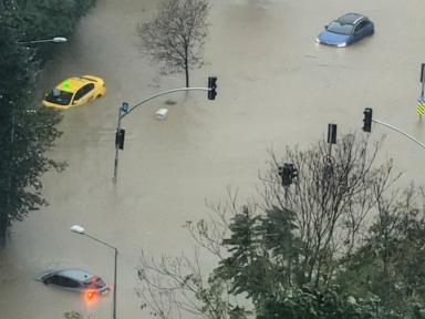
Standard breaking news coverage of severe weather closures treats a meteorological event and an administrative shutdown as a simple two-step chain: heavy rain falls, so schools close. That surface-level framing misses the operational physics of a megacity where runoff velocity, impervious surface area, transit bottlenecks, and risk governance collide under extreme precipitation. This analysis deconstructs the closure mechanism behind Istanbul flooding events into a structured decision model, separating verified operational dynamics from educated hypotheses and providing a tactical framework for municipal and institutional risk managers.
Deconstructing the Standard Headline Logic
Conventional reporting on Istanbul storm closures follows a predictable sequence: intense downpours trigger localized inundation, surface roads slow or fail, and the governor's office orders schools shut while granting administrative leave to selected public employees. While accurate as a chronology, this narrative treats the weather shock as the sole active variable.
In practice, a school closure in a city spanning two continents and millions of daily commuters is a load-shedding decision. When runoff volume exceeds drainage capacity and transit networks lose predictability, keeping thousands of campuses open forces distributed, uncoordinated movement across high-risk corridors. Closing schools removes a massive, time-concentrated wave of morning and afternoon trips—students, parents, teachers, and support staff—before gridlock hardens into stranding.
What standard coverage leaves unexamined is the lag between rainfall intensity and systemic breakdown. Flash flooding in dense urban basins does not wait for formal municipal bulletins; water accumulates in depressions, underpasses, and low-lying channels while commuters are already in transit. A headline stating that heavy rain forced closures compresses hours of cascading friction into a single cause-and-effect line.
The Four Pillars of Urban Flood Disruption
To understand why heavy rain in Istanbul translates rapidly into institutional shutdowns, analysts must evaluate four interacting systems rather than looking solely at millimeter totals on a weather gauge.
1. Hydrological Load and Surface Imperviousness
Rainfall becomes a flood hazard when precipitation rate outpaces soil infiltration, detention storage, and conveyance capacity. Across heavily urbanized districts, asphalt, concrete rooftops, and compacted ground replace permeable soil, converting a high share of falling rain directly into surface overland flow.
When extreme convective cells or prolonged frontal bands dump heavy rain over short windows, peak discharge spikes faster than older or constrained drainage conduits can clear it. In basins where stormwater and wastewater share conveyance pathways, heavy inflow increases the risk of surcharge and backflow, compounding surface water hazards with sanitation contamination.
2. Topographic Concentration and Chokepoints
Istanbul's varied topography—steep slopes meeting valleys, coastal margins, and low-lying arterial routes—channels runoff along predictable paths. Water accelerates down inclines and pools in natural basins, grade separations, and underpasses where road geometry sits below surrounding grade.
A single flooded underpass or arterial segment does more than block the vehicles directly in front of it. Upstream queues back up into feeder streets, disabling alternative routes and turning localized ponding into a corridor-wide stall.
3. Commuter Exposure and Mobility Fragility
School schedules anchor daily urban mobility. Morning drop-offs overlap with peak work commutes, creating a high-density window on buses, rail feeders, ferries, and private vehicles. When heavy rain hits during or immediately before this window, two failure modes emerge simultaneously:
- Speed compression: Reduced visibility, hydroplaning caution, and standing water force drivers to lower speeds, cutting effective roadway throughput sharply even on segments that are not impassable.
- Vehicle immobilization: Stalled cars in deeper pockets of water act as physical barriers in remaining lanes, converting passable arterials into dead ends.
Educated hypothesis: When public authorities pair school closures with selective public-sector leave or stay-at-home advisories, the primary operational goal is likely to suppress peak-hour trip generation and prevent stranded families from attempting high-risk pickups once storm conditions deteriorate.
4. Institutional Risk Governance and Lead Time
Closing schools carries immediate social and economic costs: working parents face childcare disruptions, instructional days are lost, and make-up schedules must be absorbed. Conversely, keeping schools open during severe weather exposes authorities to safety liability and operational chaos if roads flood mid-day.
Authorities therefore operate under asymmetric information and decision latency. Meteorological forecasts provide probability bands and regional warnings, whereas street-level flood depth varies block by block. Issuing a closure order early maximizes safety margin at the cost of occasional false positives if the heaviest rain shifts; waiting for confirmed widespread flooding protects against false alarms but increases the chance that students and staff are already mid-commute.
Cause-and-Effect Chains Standard Coverage Misses
A rigorous operational review highlights four second-order linkages that rarely appear in brief breaking reports:
- Drainage bottleneck to transit gridlock: Overwhelmed street inlets and low-lying road dips flood first, stalling vehicles and shrinking lane counts. The resulting traffic jam traps emergency and maintenance vehicles, delaying pump deployment and debris clearing along the very corridors needed to drain the road.
- Combined sewer surcharge to secondary hazard: Where stormwater and sewage share capacity during extreme downpours, hydraulic overload can push diluted wastewater onto streets or into ground-level spaces. What begins as a hydrological event becomes a public health and property-remediation problem that lingers after the rain stops.
- Prior moisture state to flash-flood sensitivity: Heavy rain falling onto already saturated ground or active river/stream channels produces far faster runoff than rain on dry, high-capacity storage. Past drought cycles do not guarantee immunity from severe inundation; shifts between dry stretches and intense rainfall events can test infrastructure under abrupt swings in hydrological demand.
- Closure timing to parental trip spikes: An announcement made after morning transit is underway can trigger reactive car trips as parents rush to retrieve children or check on facilities, partially offsetting the intended traffic reduction unless clear shelter-in-place guidance accompanies the order.
Operational Playbook for Extreme Rain Closures
Practitioners managing municipal operations, school districts, or enterprise continuity during severe flood alerts can apply a five-step decision workflow:
- Establish a composite trigger matrix: Do not rely on a single 24-hour rainfall forecast. Combine hourly intensity thresholds, soil/basin saturation indicators, historical flood hotspot status, and forecast timing relative to peak school and commute windows.
- Pre-position critical response assets before onset: Stage mobile pumps, gully-clearing crews, and traffic-control units near known low-lying chokepoints and school access roads prior to peak downpour hours rather than dispatching only after calls surge.
- Synchronize school and workplace demand signals: Align school closure notices with staggered hours, remote-work guidance, or public-sector leave policies so trip suppression works as a coordinated system rather than leaving half the household in transit.
- Issue explicit movement rules, not just facility status: Specify whether students and staff should shelter in place at school, delay travel, or avoid specific flood-prone corridors, reducing panic-driven vehicle surges.
- Audit post-event chokepoints and drainage performance: After water recedes, log every flooded underpass, stalled bus route, and drained basin to update next season's trigger thresholds and maintenance priorities.
Boundaries and Limitations of This Framework
No analytical model or closure protocol eliminates flood risk in a dense, topographically complex city facing extreme rainfall. Convective storms can drop intense rain over narrow footprints that coarse regional forecasts resolve imperfectly, meaning localized flash flooding can still occur outside the highest-alert zones. Furthermore, administrative closures manage human exposure and traffic load; they do not expand physical pipe capacity, restore permeable land cover, or prevent structural damage to vulnerable low-lying buildings during record downpours.
Strategic Play for Resilience
Treat recurring flood closures as an early-warning diagnostic of urban exposure rather than a standalone weather anomaly. Municipal leaders and institutional planners should pair real-time hydrological and traffic-chokepoint monitoring with targeted corridor hardening—prioritizing chronic underpass bottlenecks, keeping storm grates and channels clear ahead of wet seasons, and publishing transparent closure thresholds so households and organizations can plan around extreme rain events with far less last-minute friction.


