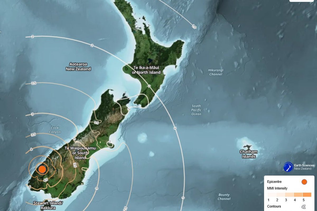
The operational integrity of early warning systems depends entirely on balancing false-alarm costs against the catastrophic risk of under-response. When a high-magnitude seismic event occurs near highly populated or economically significant areas, the protocols executed by crisis management agencies illuminate the structural friction between raw data acquisition and public safety deployment. The July 16, 2026, earthquake in New Zealand's South Island offers a precise case study in how these systems calibrate response mechanisms in real time under conditions of high velocity and imperfect data.
The event, initially estimated at a magnitude of 6.3 before being finalized at 5.9, struck the lower South Island with an epicenter located roughly 40 kilometers north of Te Anau. This location sits on the periphery of the Fiordland region, placing immediate risk on high-density tourism zones like Milford Sound and Queenstown. Because New Zealand occupies the boundary zone between the Australian and Pacific tectonic plates, its emergency infrastructure operates under a permanent threat model. Evaluating this specific response requires breaking down the event into three operational dimensions: seismic physics, early warning calibration latency, and maritime threat mechanics. You might also find this similar article useful: The Anatomy of Asymmetric Diplomacy: Deconstructing the Iranian Hostage Release Asset Valuation.
The Seismic Physics of Deep Fault Displacements
To evaluate why a tsunami warning was generated and subsequently retracted, one must first isolate the physical dimensions of the rupture. Media reports frequently conflate magnitude with surface destruction, ignoring the deep-earth mechanics that dictate real-world impact.
- Magnitude and Energy Dissipation: The initial reading of 6.3 suggested an energy release capable of severe localized destruction and significant sea-floor displacement. The subsequent downward revision to 5.9 represents an exponential reduction in calculated energy. Because seismic magnitude operates on a logarithmic scale, a drop of 0.4 units indicates the earthquake released roughly four times less energy than initially calculated by automated instruments.
- Hypocentral Depth Mechanics: The United States Geological Survey (USGS) and GeoNet isolated the hypocentral depth at 50 to 76 kilometers. In seismology, depth acts as a natural dampening filter. A deep-focus or intermediate-focus earthquake absorbs a large portion of its destructive S-waves and surface waves within the crust before reaching the surface. This structural bottleneck explains why, despite over 20,000 felt reports across the South Island, zero infrastructure failures or casualties occurred.
- Tsunami Generation Constraints: Tectonic tsunamis require large-scale vertical displacement of the seafloor, typically caused by shallow thrust-faulting under the ocean. A rupture depth exceeding 50 kilometers beneath the mainland or close to coastal margins rarely generates the massive vertical seafloor displacement required to displace a significant water column.
Early Warning Calibration Latency and Protocol Triggers
The core operational challenge for New Zealand’s National Emergency Management Agency (NEMA) lies in the trade-off between speed and accuracy. The timeline of the July 16 event highlights how modern warning systems use a tiered filtering process to manage this friction. As extensively documented in recent articles by The New York Times, the results are widespread.
[Seismic Event Occurs]
       │
       ▼
[Automated Sensor Capture] ──> Triggers Initial 6.3 Estimate (High Risk)
       │
       ▼
[NEMA Protocol Trigger] ─────> Issues Immediate Evacuation Warning (Milford Sound)
       │
       ▼
[Human-in-the-Loop Review] ──> Recalibrates Data to 5.9 Magnitude at >50km Depth
       │
       ▼
[System Downgrade] ──────────> Shifts Threat Level from Inundation to Marine Advisory
First-tier alerts rely on automated sensor networks that prioritize speed to give coastal populations maximum evacuation lead time. These algorithmic models use initial wave arrivals to guess the scale of the event. Under this baseline protocol, any estimated coastal or near-coastal rupture over magnitude 6.0 triggers an immediate, precautionary tsunami evacuation order. This explains the prompt mandate for residents and travelers in Milford Sound to seek higher ground.
Second-tier optimization occurs when human-in-the-loop validation corroborates automated telemetry with broader regional sensor arrays. As more station data trickled in, analysts corrected the system’s initial overestimate down to 5.9. Once the revised magnitude and deep hypocenter were verified, the physical probability of land inundation dropped below critical thresholds, allowing NEMA to downgrade the warning to a marine advisory.
While critics often view downgrades as systemic errors, they actually demonstrate a highly optimized protocol doing exactly what it was designed to do: minimizing time-to-alert at the start of an event, then refining the response as data fidelity improves.
The Hydrodynamic Friction of Marine Advisories
A common misconception is that a downgraded tsunami warning means the hazard has entirely passed. NEMA’s shift from an evacuation warning to a marine advisory highlights a different type of risk profile: hydrodynamic friction along the shoreline.
Even when an earthquake fails to generate a towering tsunami wave, deep-water seismic energy still transfers into the ocean, creating long-period waves. When these waves enter shallow coastal waters, inlets, and fiords—such as Milford Sound—they undergo a process called bathymetric shoaling. The wave slows down, its length compresses, and its height increases.
This does not cause massive inland flooding, but it does create violent, erratic currents and unpredictable sea-level surges. For vessels, deep-water ports, and mariners, this hydrodynamic activity presents severe risks:
- Vessel Grounding: Sudden, localized drops in sea level can ground vessels in shallow channels.
- Mooring Failures: High-velocity currents inside narrow fiords strain and snap heavy mooring lines, turning unanchored ships into floating hazards.
- Rip Currents: Turbulent coastal currents increase rapidly, making the immediate shoreline highly dangerous for anyone near the water.
NEMA's directive for vessels to return to shore or head to deep water reflects standard maritime risk mitigation. Deep-water vessels are safer in open ocean conditions where long-period waves have low amplitudes and pass beneath hulls undetected.
Strategic Resource Allocation in High-Frequency Seismic Zones
The Te Anau event is a reminder of a long-term risk management challenge facing New Zealand's infrastructure: Alpine Fault rupture preparedness. Local reactions to the shaking—such as the widespread concern that this event was the long-predicted "Big One"—reflect the psychological reality of living near a major fault system.
The Alpine Fault runs along the spine of the South Island and has a highly regular historical recurrence interval. Geological data suggests it has a high probability of generating a magnitude 8.0+ event in the coming decades. Emergency agencies must continually run safety drills and manage public expectations without causing warning fatigue.
If an emergency agency issues too many false alarms or handles warning downgrades poorly, the public can develop a dangerous numbness to alerts. This behavioral bottleneck can lead to slower evacuation times during a real crisis. NEMA's handling of the July 16 event offers a clear framework for managing this risk: state the maximum potential threat immediately to protect human life, use clear criteria for changing the alert level, and provide transparent explanations for data adjustments to maintain public trust.
The operational takeaway for regional logistics managers, tourism operators, and civil authorities is clear: emergency frameworks must not rely on a single, static prediction. Instead, they must build flexible operational systems that can scale up or down as fast as a seismic wave moves through rock.