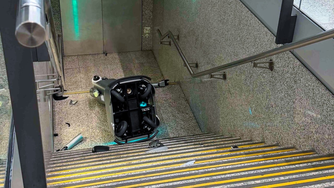
Autonomous service units operating in high-density public infrastructure face a persistent operational vulnerability: the boundary between structured surface navigation and unstructured edge environments. When a security and patrol robot operated by the Airport Authority Hong Kong tumbled down a flight of stairs at the passenger terminal, the incident offered a clear case study in spatial computing failure. Observers often reduce such events to simple hardware malfunctions or software glitches. A rigorous engineering post-mortem reveals a multi-layered breakdown spanning sensor occlusion, path planning heuristics, and environment-map discrepancies.
Operating service robotics within an international aviation hub requires managing thousands of dynamic variables simultaneously. Terminals are high-entropy zones characterized by shifting crowd densities, reflective flooring, and architectural anomalies like escalators, travelators, and open stairwells. When an autonomous mobile robot exits its designated operational design domain, system failure is typically the result of compounding assumptions within the perception-action loop rather than a single component defect. You might also find this connected story insightful: Why NASA is Betting Everything on the Roman Space Telescope Launch.
The Perception Gap in Structured Indoor Environments
The primary driver of autonomous navigation failures is sensor degradation caused by environmental properties. Most indoor service robots rely on a sensor suite comprising Light Detection and Ranging units, ultrasonic sensors, depth cameras, and wheel encoders. Each modality possesses distinct physical limitations that become magnified in expansive, modern airport terminals.
LiDAR relies on the emission and reflection of laser pulses to construct a two-dimensional or three-dimensional point cloud of the surroundings. Smooth, highly polished stone or tile flooring commonly found in major airports creates specular reflection. Instead of returning a clean scatter pattern, laser beams bounce off the floor at oblique angles, causing the perception system to misinterpret open space as solid ground, or conversely, solid ground as a void. As highlighted in latest coverage by MIT Technology Review, the implications are worth noting.
Optical depth cameras face similar failure modes when exposed to uneven ambient lighting conditions. Large glass facades introduce intense direct sunlight, which saturates complementary metal-oxide-semiconductor sensors and blinds the machine vision pipeline. If the illumination shifts abruptly from shadow to direct glare, the visual odometry fails to track surface features accurately.
Ultrasonic sensors, utilized for close-range collision avoidance, suffer from acoustic absorption issues and specular reflection on hard surfaces. Sound waves striking a glass wall or a sharp vertical drop at an angle will deflect away from the transducer rather than returning to the receiver. The robot's central processing unit registers a zero-distance reading or an empty return, interpreting the lack of a return signal as an unobstructed path forward.
Path Planning Heuristics and Spatial Map Drift
Once perception data is filtered, the localization and mapping subsystem matches the current sensor observations against a pre-loaded grid map of the terminal. This process, commonly implemented via Simultaneous Localization and Mapping algorithms, calculates the robot's coordinates within a probabilistic framework.
Map drift occurs when minor cumulative errors in wheel odometry and inertial measurement units diverge from the actual physical position. If the robot's onboard software believes it is positioned two meters to the left of its actual location due to slip on a polished floor or wheel lockup, the local costmap will project safe traversable space over an actual physical hazard, such as a stairway landing.
Global path planners establish the route from point A to point B, while local planners execute real-time obstacle avoidance. The failure at the Hong Kong terminal indicates a breakdown in the local reactive layer. A robust architecture should implement redundant safety stops, such as cliff-detection infrared sensors angled downward toward the floor surface at the chassis perimeter. If these sensors register an infinite depth drop, an emergency brake command must override all path-planning velocities.
When an autonomous system drops off a ledge, it indicates that the cliff-detection sensors were either physically occluded by dust or structural design, improperly calibrated, or ignored by the priority arbitration layer of the robot's operating software. In high-traffic public spaces, dust accumulation on optical lenses and sensor windows degrades performance rapidly over a span of operational hours. Without automated self-diagnostic routines or active cleaning mechanisms for sensor covers, perception degradation remains an unmanaged variable.
The Human-Robot Interaction and Operational Oversight Void
Autonomous deployment models in commercial spaces often suffer from an over-reliance on remote monitoring dashboards. Control room operators manage fleets of dozens or hundreds of units, relying on exception-based alerting systems. When an anomaly occurs, the time constant for human intervention is bounded by network latency, operator cognitive load, and situational awareness transfer.
If a robot experiences a localization failure, it may output a low-severity warning code rather than a critical stop notification. Operators accustomed to frequent false positives or minor warning flags may fail to intervene before the physical boundary condition is breached. The operational architecture must account for the reality of human latency by enforcing hard physical limits within the firmware layer rather than relying on software-level compliance checks.
Furthermore, dynamic physical modifications in terminal environments create persistent hazards for automated units. Temporary construction barriers, relocated stanchions, or maintenance work often alter the geometric layout faster than facility managers can update the central mapping databases. If the robot's real-time obstacle detection fails to identify a newly uncovered or poorly marked hazard, the software defaults to the historical map layer, treating a dangerous architectural edge as a validated, safe pathway.
Architectural Requirements for Safe Terminal Autonomy
Mitigating the risk of stairwell descents and structural falls requires a systematic overhaul of robot design standards for public-facing deployments. Software redundancy is insufficient when the underlying physical sensors fail to capture reality accurately.
First, multi-modal validation must govern edge detection. A safety-critical system should never rely on a single sensor type to identify a drop-off. Fusing LiDAR returns with downward-facing Time-of-Flight sensors and mechanical bumper switches creates a triple-redundant safety net. If any single modality detects an anomaly or an infinite distance drop, the motor controller must execute an immediate hardware-level power cut to the drive wheels.
Second, operational design domains must be geographically fenced using hardware-interlocked virtual boundaries rather than purely software-enforced geofences. Radio-frequency identification tags embedded in the flooring near stairwells, escalators, and structural ledges can provide an independent, absolute positional trigger that forces a robot to halt or reverse direction, even if the primary localization algorithm fails entirely.
Third, velocity profiles must scale inversely with environmental predictability. In zones adjacent to architectural hazards, speed limits should be constrained to low thresholds that allow immediate stopping within a fraction of the sensor's maximum detection range. Kinetic energy scales with the square of velocity; reducing operating speed near complex geometries exponentially increases the time available for reactive sensor processing and braking execution.
Deploying autonomous systems in unconstrained environments necessitates treating every surface transition as a potential point of catastrophic failure. The incident at the Hong Kong terminal underscores the necessity of moving away from fragile, software-dependent navigation models toward hard-bounded, multi-sensor verification architectures that assume environmental hostility by default.
Allocate dedicated capital expenditure toward upgrading perimeter sensor suites on legacy hardware fleets to include active infrared cliff-detection arrays, and establish mandatory hardware-level kill switches tied directly to physical drop-off sensors before expanding autonomous patrol routes into multi-level public infrastructure.