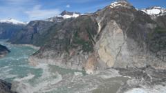
The 2015 Taan Fiord megatsunami represents a definitive case study in the mechanics of subaerial-to-aquatic energy transfer. Triggered by a massive rockslide at the terminus of Tyndall Glacier in Icy Bay, Alaska, the event generated a localized wave reaching a maximum run-up height of 193 meters (633 feet). This magnitude places it as the fourth highest megatsunami recorded in the last century and the second largest since the 1958 Lituya Bay event. To understand the scale of this displacement, one must move beyond the "massive wave" narrative and analyze the event through the lens of kinetic energy conversion, bathymetric constraints, and the destabilizing feedback loops created by retreating glacial masses.
The Mechanics of Subaerial Displacement
Landslide-generated tsunamis differ fundamentally from seismic tsunamis. While seismic events involve the vertical displacement of the seafloor across vast areas, megatsunamis are characterized by a concentrated, high-velocity mass entering a confined body of water. The Taan Fiord event was governed by three distinct physical variables:
- Mass Volume and Velocity: Approximately 76 million cubic meters of rock (roughly 200 million tons) detached from the mountain face. The gravity-driven acceleration of this mass provided the primary energy input.
- Impact Geometry: The angle at which the debris entered the water dictated the efficiency of energy transfer. In Taan Fiord, the steep descent ensured that a significant percentage of the potential energy was converted into a solitary wave rather than being dissipated through turbulence or heat.
- Confined Bathymetry: The narrow, deep nature of the glacial fiord prevented the wave energy from radiating outward in a 360-degree arc. Instead, the energy was funneled along the axis of the fiord, maintaining wave height over a longer distance than would be possible in an open ocean environment.
The resulting wave was not a traditional "breaker" but a wall of water displaced by the sheer volume of the incoming rock. As this volume moved, it pushed the water column upward and outward, seeking equilibrium. The 193-meter measurement refers specifically to "run-up"—the elevation above sea level to which the water climbed as it hit the opposite shoreline—rather than the height of the wave while in transit through the center of the fiord.
The Glacial Retreat Feedback Loop
The Taan Fiord event serves as a primary indicator of "paraglacial" risk. This term describes the transition period where landscapes previously supported by glacial ice become unstable following the ice's retreat. The Tyndall Glacier had retreated approximately 17 kilometers between 1961 and 1991, thinning by over 400 meters in some sections. This retreat removed the physical "buttress" that held the mountain walls in place.
The Structural Weakness Formula
The stability of the fiord walls can be modeled as a balance between the internal friction of the rock and the external pressure applied by the glacier. When the glacier thins, two critical changes occur:
- Debuttressing: The removal of ice weight creates a "pressure release" in the rock, leading to the expansion of existing fractures and joints.
- Thermal Destabilization: As ice vanishes, the rock face is exposed to seasonal freeze-thaw cycles. Water enters cracks, expands upon freezing, and wedges the rock apart, a process known as frost wedging.
In Taan Fiord, the rockslide did not occur during a storm or an earthquake. It was the result of a slow, cumulative degradation of structural integrity that reached a tipping point. This suggests that in regions of rapid deglaciation, "spontaneous" mass wasting events are a predictable outcome of the current geological trajectory.
Quantifying Energy Transfer and Wave Propagation
The energy required to lift millions of tons of water to a height of nearly 200 meters is staggering. To quantify the impact, researchers look at the "Froude number," a dimensionless value representing the ratio of the flow inertia to the external field (gravity). In megatsunami events, the Froude number of the landslide often exceeds 1, meaning the debris is moving faster than the wave it generates, effectively "plowing" the water.
Wave Evolution Stages
- Generation Phase: The first 60 seconds. The rockslide hits the water, creating a massive splash and a displacement wave. This phase is dominated by non-linear fluid dynamics where water and debris are mixed.
- Propagation Phase: The wave travels down the fiord. Because the water depth in Taan Fiord varies, the wave undergoes "shoaling." As the water becomes shallower, the bottom of the wave slows down due to friction, causing the top to rise even higher.
- Inundation and Run-up Phase: The wave hits the shore. The kinetic energy is converted back into potential energy as the water surges up the mountain slopes, stripping away centuries of soil and vegetation.
The forensic evidence left behind—specifically the "trimline," the sharp boundary where forest was removed—allowed scientists to calculate the exact height of the water long after it had receded.
Risk Assessment in the New Arctic
The Taan Fiord event is not an isolated anomaly but a blueprint for future hazards in the Arctic and sub-Arctic. As permafrost thaws and glaciers continue to thin, the probability of similar megatsunamis increases in Greenland, Norway, and Chile.
The Monitoring Gap
Current global tsunami warning systems are designed for seismic events. They rely on deep-sea pressure sensors (DART buoys) and coastal tide gauges. These systems are ineffective for megatsunamis because:
- Time Scales: The interval between the landslide and the wave impact is often less than two minutes. Traditional warning systems cannot process data that quickly.
- Localization: The damage is often confined to a single bay or fiord, making it a "micro-disaster" from a global monitoring perspective, yet a total catastrophe for any local shipping, fishing, or tourism infrastructure.
The strategic response requires a shift toward high-frequency satellite interferometry (InSAR) to monitor slope deformation in real-time. By measuring millimeter-scale movements in mountain walls above retreating glaciers, it is possible to identify "unstable slopes" before they fail.
Strategic Play for Coastal and Marine Infrastructure
For stakeholders operating in glaciated marine environments, the Taan Fiord data dictates a move away from historical safety margins. Infrastructure planning must now incorporate "mass-wasting inundation zones."
- Mapping Vulnerability: Authorities must prioritize the bathymetric and topographic mapping of all fiords with retreating glaciers. Identifying "perched" debris flows is the only way to establish a baseline for potential wave heights.
- Sensor Deployment: Terrestrial radar interferometry should be deployed at high-risk sites to monitor slope creep. This provides the only viable early warning window—potentially days or weeks of lead time based on accelerating movement—rather than the seconds provided by water-level sensors.
- Operational Rerouting: Shipping lanes and temporary camps must be positioned outside of the calculated run-up zones. The Taan Fiord data proves that even a distance of several kilometers from the impact site offers no protection if the vessel is in the direct path of the energy funnel.
The geological record in Taan Fiord confirms that the "second largest" tag is a temporary designation. As the cryosphere destabilizes, the frequency of these high-magnitude displacement events will likely outpace historical averages, necessitating a fundamental redesign of Arctic risk management frameworks.