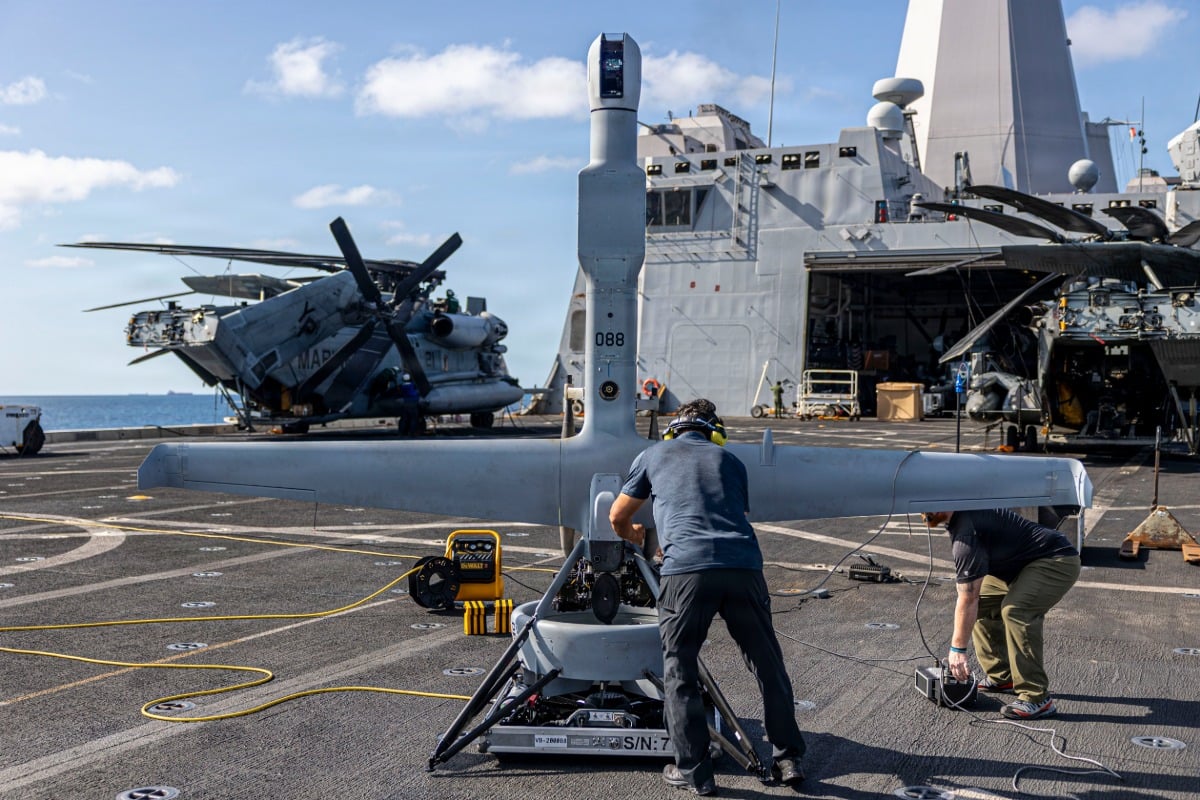
The Pentagon is changing how it watches the South China Sea, and it does not involve massive, multi-million-dollar aircraft. Instead, U.S. Marines are launching small, catapult-mounted surveillance drones straight from the decks of warships navigating these heavily contested waters.
It is a quiet shift in naval strategy. For years, maritime intelligence relied on massive reconnaissance planes or high-altitude assets. Those still matter. But the immediate future of tracking island bases and maritime militia fleets belongs to compact, tactical uncrewed aerial systems.
The Reality of Marine Drone Operations in the Pacific
The U.S. Marine Corps has been actively deploying the MQ-27B ScanEagle and similar tactical drones from amphibious transport docks and expeditionary sea bases. These operations are not just routine exercises. They are happening directly within the first island chain, a region where China maintains a heavy concentration of naval and coast guard vessels.
Why use a drone that looks tiny compared to a fighter jet? It comes down to logistics and staying hidden.
Large aircraft require massive runways or full-sized aircraft carriers. They make big targets. A tactical drone can launch from the stern of a relatively small ship using a pneumatic catapult. When it finishes its flight, a skyhook system catches it out of the air. No runway needed. No massive footprint.
This footprint matters because of how the Marines plan to fight. The current doctrine, known as Expeditionary Advanced Base Operations, focuses on small units moving rapidly between remote islands. They must operate inside the weapon engagement zone of an adversary. If a unit relies on a massive logistics chain, it fails.
Tracking the Gray Zone Without Escalation
The South China Sea is notorious for gray zone warfare. This involves the deployment of fishing vessels, maritime militia, and coast guard ships to assert territorial claims without triggering a full military conflict.
Tracking these vessels is a constant headache. Satellites offer glimpses but cannot provide continuous, real-time video feeds over a specific coordinates for twelve hours straight.
Tactical drones bridge this gap. They fly low, stay in the air for long periods, and carry electro-optical and infrared sensors. Marines on the warship watch live video feeds of Chinese artificial island bases, tracking ship movements and construction in real time.
Using these assets also lowers the stakes. If an adversary jams or shoots down a small, uncrewed drone, it causes an international incident, but nobody dies. It prevents the immediate escalation that comes with a manned aircraft getting targeted.
The Technical Reality of Tactical Naval Drones
Operating a drone from a moving ship in the open ocean is incredibly difficult. The wind changes constantly. The deck rolls and pitches.
The systems used by the Marines rely on automated recovery systems. The drone flies into a vertical rope suspended from a jackmast on the ship. The wingtip latches onto the rope, securing the aircraft safely.
- The system requires minimal personnel to operate, freeing up crew members for other tasks.
- The aircraft uses heavy fuel, which matches the standard fuel types carried on Navy warships, simplifying the supply chain.
- The sensor payloads can switch out quickly, allowing teams to pivot from day surveillance to night tracking in minutes.
Military planners emphasize that these small systems provide local commanders with immediate situational awareness. They do not have to wait for a higher command to route satellite imagery or task a strategic asset. The data goes straight to the ship coordinates where decisions are being made.
What This Means for Regional Security
This shift toward distributed, ship-launched surveillance directly counters the anti-access and area-denial strategies implemented by regional competitors. By scattering sensor platforms across dozens of smaller ships rather than concentrating them on a single carrier strike group, the U.S. military makes its surveillance network much harder to disrupt.
It also changes the calculation for regional coast guards and maritime militias. They can no longer assume they are operating out of sight just because no large gray hulls or American reconnaissance planes are visible on the horizon. The eye in the sky is already there, launched from a ship miles away, quietly sending coordinates back to the fleet.