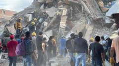
A magnitude 7.4 earthquake originating near San José del Palmar in the Chocó region of Colombia has exposed the complex friction points between tectonic energy release, urban infrastructure density, and emergency logistics. Recording a depth exceeding 100 kilometers, the seismic event generated widespread structural failures across departmental capitals including Cali, Pereira, Quibdó, and Manizales, resulting in a provisional death toll surpassing 180 individuals alongside thousands of reported injuries. Deconstructing this disaster requires evaluating three core variables: energy dissipation depth, urban asset vulnerability, and logistical response latency.
The Depth Energy Dissipation Equation
Seismic destructiveness is governed not merely by surface magnitude ratings, but by hypocentral depth and geological wave propagation paths. The Colombian Geological Service registered this event at a depth of approximately 103 kilometers.
An intermediate-depth earthquake of magnitude 7.4 behaves differently than a shallow crustal rupture of identical magnitude. Deep-focus events attenuate higher-frequency ground motions over shorter distances, which typically reduces localized absolute peak ground acceleration near the immediate epicenter. However, regional basin effects and softer sedimentary structures in valley corridors can trap and amplify seismic wave energy, transferring destructive resonance frequencies hundreds of kilometers away.
This mechanism explains why structural damage concentrated heavily in urban centers like Cali and Pereira rather than the sparsely populated immediate epicenter of San José del Palmar. The seismic waves propagated through Andean sub-structures before surfacing with high differential displacement in urban zones characterized by varying building stock resilience.
Urban Asset Vulnerability and Spatial Clustering
The spatial distribution of casualties indicates a stark structural discrepancy between metropolitan centers and peripheral zones. Data from municipal tracking organizations show that the vast majority of confirmed fatalities occurred within departmental capitals rather than rural communities. This concentration stems from asset density and architectural typology rather than seismic intensity gradients alone.
Unreinforced masonry structures, multi-story concrete frame buildings predating modern seismic building codes, and soft-story commercial configurations form the primary hazard vector in cities like Cali and Pereira. When subjected to prolonged cyclic lateral loading during a major tremor, these buildings experience progressive joint shear failure.
The physical vulnerability can be broken down into three structural failure modes:
- Soft-story collapse, where open ground floors used for parking or retail lack the lateral stiffness of upper residential levels.
- Pounding damage, occurring when adjacent buildings with misaligned floor heights collide during oscillation.
- Foundation liquefaction in alluvial valley basins, causing differential settlement that tilts or shears structural columns.
Conversely, while urban centers suffer from high asset vulnerability due to population density, rural regions face an inverse hazard profile: isolation vulnerability.
Logistical Response Latency and Regional Isolation
The operational efficacy of search and rescue missions depends on the temporal window defined by survivability curves. The initial 48 to 72 hours represent the critical period for extracting live victims from collapsed structures. During this window, response velocity is a direct function of supply chain integrity, transport accessibility, and command hierarchy efficiency.
In the Chocó department, where the epicenter was located, logistical friction severely restricts deployment capacity. Chocó remains one of Colombia's structurally under-resourced regions, featuring terrain where terrestrial transit corridors are limited, mountainous, and vulnerable to secondary landslide blockages. Towns along river networks require hours or days of boat transit to access, creating an acute information asymmetry. While metropolitan capitals rapidly transmit damage assessments and mobilize localized municipal machinery, remote municipalities suffer from prolonged reporting delays.
Furthermore, civil security challenges compound logistical deployment. The presence of armed non-state actors in rural Pacific corridors introduces friction into humanitarian access, mirroring historical bottlenecks where medical and rescue personnel faced movement restrictions. Emergency command structures must therefore balance security escorts with rapid triage deployment, slowing down the mean time to treatment for peripheral victims.
Resource Allocation and Economic Shock Absorption
A natural disaster of this magnitude triggers immediate liquidity demands on national fiscal reserves. The declaration of a national disaster and the activation of emergency funding decrees serve to bypass normal bureaucratic procurement latencies, allowing the Ministry of Finance to reallocate capital toward temporary housing deployment, patient airlifts to medical centers in Medellín, and heavy debris-removal engineering assets.
However, fiscal injection alone does not resolve the immediate supply constraints of specialized heavy rescue gear. Urban search and rescue operations require acoustic sensors, thermal imaging, and shoring materials that are finite within domestic inventories, necessitating international technical assistance coordination.
Deploy a centralized, tiered triage protocol prioritizing capital-intensive heavy rescue teams to high-density structural collapse zones in Cali and Pereira while concurrently utilizing rotary-wing aircraft to bypass geographic and security bottlenecks in rural Chocó river communities within the first 36 operational hours.