The air in the high valleys of Nepal smells of cedar smoke, damp earth, and a distinct, iron-rich sharpness that comes only from freshly exposed stone. If you stand long enough on a ridge overlooking the lower flanks of the Annapurna range, you stop hearing the wind as mere weather. It sounds like a slow tearing.
For generations, the people of these high settlements measured wealth not in currency, but in green. A hillside heavy with broad-leafed trees and dense root systems meant security. It meant fuel for the winter hearth, fodder for the goats, and, most crucially, a living shield against the monsoon skies. The soil stayed where it belonged. The water found its way downward through a thousand patient, mossy capillaries. You might also find this similar coverage interesting: Why the Nepal Flash Floods Weren't Caused by an Earthquake.
Then came the satellites.
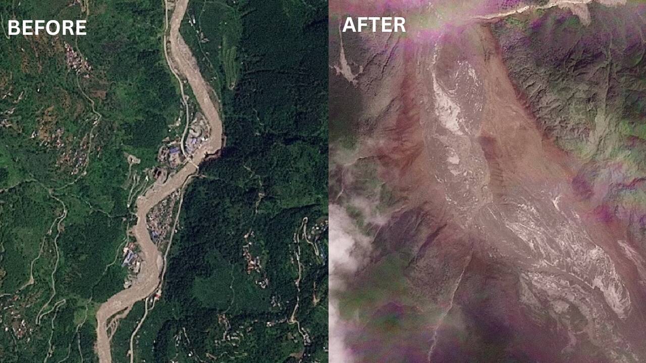
From hundreds of miles above, peering down through lenses that care nothing for human history, the orbiters began to paint a different picture. Where there was once a heavy, dark velvet of green, patches of chalky gray began to bleed outward. Year by year, the scars widened. What looked like harmless brown veins on a monitor were, in reality, massive tracts of mountainside giving way to gravity and water. As extensively documented in latest reports by USA Today, the effects are worth noting.
Call it erosion if you like. That is the sterile word used in engineering reports. But down here, where the mud pools against the doorframes after a heavy night of rain, it is called disappearing.
To understand what happened to the green mountainsides, you have to look at how a mountain actually holds itself together. Think of it as a tightly woven woolen sweater worn by a giant. Every root is a thread. Every shrub is a knot. When the rains come—not the gentle mist of poetry, but the heavy, hammering monsoons that drop feet of water in a matter of weeks—the sweater takes the blow. The roots grip the dirt, locking millions of tons of earth into place.
For a long time, the system held. The human footprint was light. Terraces were carved into the slopes with hand tools, meticulously engineered by ancestors who understood that water must be walked down a mountain, never allowed to run.
But population pressures grow. Roads push deeper into the interior, cutting notches into the toes of ancient slopes to let trucks pass. When you slice away the bottom of a steep hill to carve a dirt highway, you pull the bottom out of the sweater.
Consider what happens next. The first heavy downpour hits the raw, unanchored cut above the road. Water fills the tiny gaps in the soil, adding immense weight. Without roots to bind the particles, the earth liquefies. It does not slide politely; it drops. A debris field is born.
Satellite imagery captured this transition with horrifying clarity over the last decade. Series after series of overhead photographs show green canopies replaced by raw, white-gray scars of stone and pulverized earth. Entire hillsides simply unzipped.
I remember standing with a village elder named Pemba outside a stone tea house a few miles north of Pokhara. He pointed up toward a ridge that, in my urban ignorance, looked rugged and wild.
"That used to be our winter grazing forest," he told me, his eyes squinting against the glare of the snow peaks. "My grandfather took his cattle there when the lower pastures frosted over. Now? Nothing grows there. Even the grass refuses to hold. The soil washed out into the Trishuli River three monsoons ago."
He wasn't angry. That was the most unsettling part. He spoke with the quiet, flat exhaustion of a man watching a slow-motion eviction.
When a green mountainside turns into a debris field, the loss goes far beyond aesthetics or even the local economy. It triggers a chain reaction that echoes all the way to the plains below. The soil that was once anchored by roots now chokes riverbeds, raising the river bottoms and turning manageable seasonal floods into catastrophic inundations downstream. Reservoirs fill with silt decades ahead of schedule. Hydroelectric turbines grind to a halt, choked by pulverized granite and mud.
We tend to view nature as a backdrop—a stage set that remains static while human dramas play out across it. But the satellite photos of Nepal prove otherwise. The stage is collapsing.
There is a dangerous misconception that environmental degradation in the Himalayas is purely a natural disaster cycle, an act of angry gods. Meteorologists and geologists have the data to prove otherwise. While seismic activity plays a role, the rapid acceleration of debris flows is overwhelmingly driven by human intervention—unplanned road construction, overgrazing, and the loss of forest cover that acts as the primary shock absorber against climate-induced extreme weather events.
The monsoons are getting heavier, more erratic. Storms that used to drop rain over five days now compress that volume into five hours. The earth cannot adapt quickly enough, especially when its defenses have already been stripped away by human hands.
The satellites do not lie. They show the green retreating upward, chased by gray tongues of landslide debris. They show the rivers widening, turning the color of café au lait as they carry the lifeblood of the mountains out to sea.
Back on the ridge, the wind shifts, carrying the scent of impending rain. Down in the valley, families are already cleaning their drainage ditches, checking the concrete retaining walls they built with their own savings. They know the satellites are watching from above, recording the loss. But they also know that no photograph from space can shovel the mud off a living room floor.
The mountain is speaking. We just spent too long refusing to translate the language.