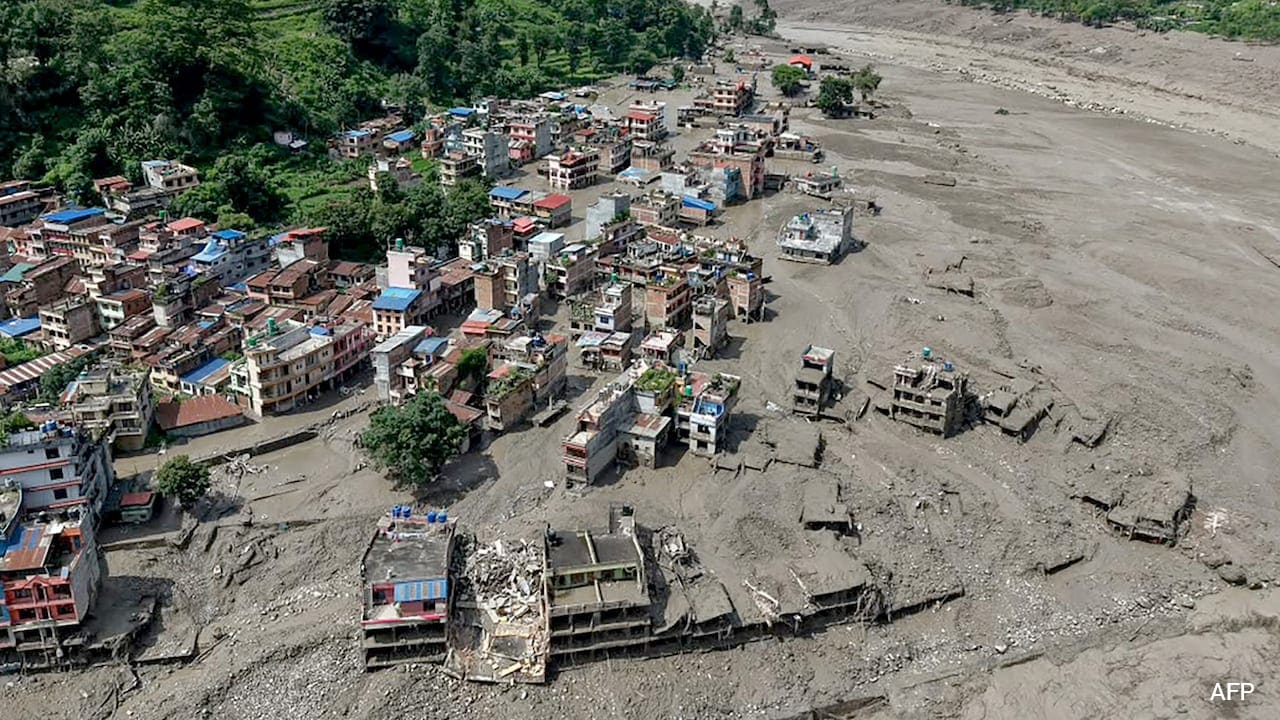
The earth moved beneath the Himalayas, and the ice followed. Recent satellite data released by the Indian Space Research Organisation confirms a terrifying geophysical chain reaction. An earthquake struck, and a massive glacier collapse immediately triggered catastrophic flash floods in Nepal. This sequence of events is not a freak anomaly. It is part of an escalating pattern of high mountain disasters that scientists have warned about for decades.
When tectonic plates grind together deep beneath the earth crust, the surface feels the violence. In high mountain ranges, that shockwave travels upward into unstable masses of ice, snow, and loose rock. When an earthquake occurs near a fragile glacial ecosystem, the structural integrity of the ice vanishes instantly.
The immediate aftermath involves sudden glacial lake outbursts and roaring walls of water tearing down narrow river valleys. Communities living downstream find themselves with minutes, sometimes seconds, to react. Understanding how seismic activity weaponizes static ice fields requires looking closely at the mechanics of high altitude geology.
The Physics of Seismic Ice Fracturing
Glaciers are not static blocks of frozen water. They are rivers of ice under immense internal stress, moving slowly downward under gravity. They balance on steep slopes, held in place by friction, bedrock anchoring, and lateral moraines.
When a seismic wave rips through a mountain, it alters that fragile balance. The ground acceleration breaks internal bonds within the ice sheet. Crevasses widen overnight. Subglacial water pressure shifts violently, lubricating the bedrock and reducing friction to zero.
The glacier does not just melt. It shatters.
Millions of tons of ice break free simultaneously. This mass avalanches down sheer cliff faces, converting potential energy into kinetic force. When that debris hits a glacial lake below, it acts like a giant piston. A displacement wave overtopping the natural moraine dam is guaranteed. The resulting flood unleashes millions of cubic meters of water, mud, and boulders into valleys below.
Scientists have tracked this phenomenon across the Hindu Kush Himalaya region with growing alarm. The intersection of active tectonics and accelerated warming creates a compounding hazard zone. Seismic monitoring alone is insufficient. Hydrological tracking alone misses the trigger. Protecting vulnerable populations requires a unified approach that treats earthquakes and glacier stability as a single, interconnected threat matrix.
Why Traditional Warning Systems Fail
Early warning infrastructure in remote Himalayan valleys faces severe operational hurdles. Rugged terrain, extreme weather, and sparse communication networks make continuous real-time data collection exceptionally difficult.
Traditional flood sensors rely on river gauge measurements. Once a river swells, the sensor triggers an alarm downstream. In a glacial flash flood caused by an earthquake, that warning margin shrinks to near zero. By the time water levels rise at a downstream gauge, the torrent is already sweeping away bridges, homes, and hydro-power infrastructure.
Traditional hazard maps also fail to account for multi hazard events. Agencies often map flood zones based on typical monsoon rainfall patterns or gradual seasonal melt. They rarely factor in the kinetic impact of a sudden seismic trigger turning a hanging glacier into an airborne avalanche of ice blocks.
Local populations bear the brunt of this institutional blind spot. Mountain communities possess deep generational knowledge of weather patterns and seasonal river flows, but earthquakes defy historical memory. A quake can alter the geography of a valley in ten seconds, rendering decades of local experience obsolete overnight.
Bridging this gap demands structural adaptation. Governments and international agencies must deploy high altitude seismic sensors linked directly to automated downstream sirens. Waiting for manual verification of a disaster guarantees casualties.
The Broader Himalayan Crisis
Nepal sits on one of the most volatile seismic zones on the planet, compressed between the Indian and Eurasian tectonic plates. At the same time, the region experiences atmospheric warming at rates significantly higher than the global average.
This dual pressure transforms the roof of the world into a ticking clock. As temperatures rise, glaciers thin out, develop internal meltwater channels, and lose their structural anchors. A stable glacier can often absorb a moderate earthquake without collapsing. A degrading, warm-core glacier cannot.
The cascading impacts extend far beyond local villages. Major river basins originating in the Himalayas support nearly two billion people downstream across South Asia. When a glacial outburst destroys a hydropower plant, regional energy grids suffer immediate instability. When sediment chokes agricultural lands, food security for millions hangs in the balance.
Mitigating these risks requires moving past crisis response. Policymakers must fund continuous satellite surveillance of high altitude lakes and unstable ice masses. Engineers need to implement controlled drainage projects for expanding glacial lakes before natural dam failures occur.
Ignoring the link between seismic activity and glacial collapse is no longer an option. The earth will keep shaking, the ice will keep warming, and the valleys below will remain in the path of the next inevitable cascade.