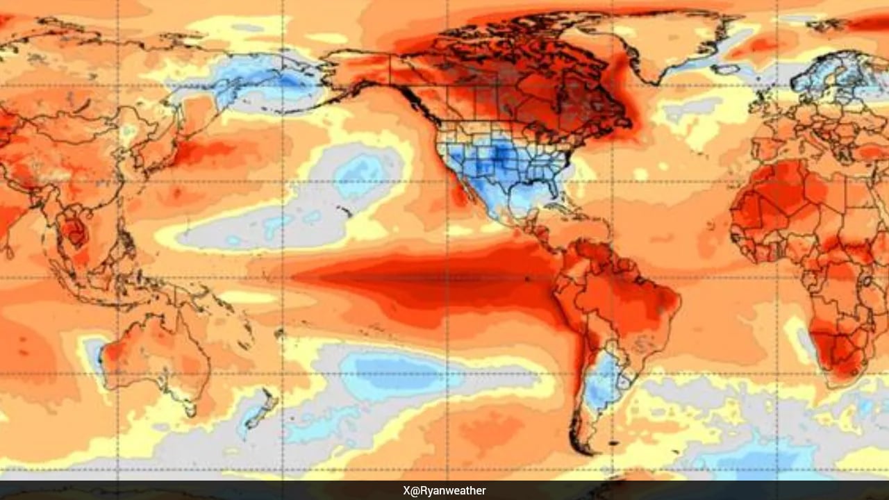
When satellite maps light up in blazing crimson, scientists pay attention. Right now, Pacific Ocean surface temperatures are climbing in a pattern that signals something massive. You've probably heard the term El Nino before, but the current warnings point toward an extreme cycle often dubbed a super El Nino. Weather charts flash a stark crimson across the equatorial Pacific, leading meteorologists to sound alarms about what happens next.
Let's cut through the noise. Weather forecasters love dramatic headlines, but the reality behind a severe El Nino cycle carries weight. This isn't just about a rainy season or a warm winter. It alters atmospheric circulation on a planetary scale. When warm water pools where it shouldn't, global jet streams shift. Droughts strike regions accustomed to reliable rainfall, while torrential downpours inundate normally dry landscapes. For another look, check out: this related article.
Understanding how this cycle works requires looking beneath the surface. El Nino is part of the El Nino-Southern Oscillation, known simply as ENSO. It swings between warm phases and cool phases, called La Nina, every few years. During a standard cycle, trade winds blow warm water toward Asia. When those winds weaken or reverse, that massive reservoir of heat sloshes back toward the Americas.
What Sets This Cycle Apart
Not all warming events are created equal. Meteorologists track subsurface ocean temperatures to gauge intensity. When heat anomalies stretch deep beneath the surface, the surface warming becomes nearly impossible to reverse quickly. That stubborn persistence is what pushes a routine climate pattern into extreme territory. Related reporting on the subject has been published by The Washington Post.
Satellites measuring sea surface heights show massive pools of warm water swelling near the equator. Historic analogs point directly to major climate disruptions, such as the severe events recorded in past decades that shattered agricultural output and spiked commodity prices worldwide. You don't need a degree in oceanography to feel the impact. Higher ocean temperatures feed moisture directly into the atmosphere, supercharging storms and intensifying marine heatwaves.
Global weather patterns do not exist in isolation. A major shift in the Pacific triggers a domino effect across other basins. Atlantic hurricane seasons often see suppressed activity due to increased wind shear, while parts of the Indian Ocean experience severe drying trends.
The Ripple Effect on Agriculture and Food Prices
Markets react quickly to climate instability. Grain belts in North America, South America, and Australia face wild swings between punishing droughts and historic floods. When crops fail, supply chains fracture.
Farmers know this drill all too well. Planting schedules get thrown into chaos when heavy rains saturate fields during prime sowing windows, or when dry spells stunt root growth before plants can mature. If you manage a supply chain or invest in commodities, ignoring these ocean signals is a costly mistake. Prices for coffee, cocoa, sugar, and wheat frequently surge in the wake of prolonged ocean warming events because growing regions take direct hits.
Beyond farming, energy grids face unprecedented strain. Extreme heatwaves drive residential and commercial cooling demand through the roof. Power grids struggle under the load, raising the risk of brownouts right when vulnerable populations need air conditioning the most.
Preparing for the Shift
Waiting for extreme weather to arrive on your doorstep is a losing strategy. Communities need to audit infrastructure long before the first heatwave or flood warning hits. Water management districts must balance reservoirs early, shifting away from reactive measures toward proactive conservation.
If you live in a wildfire-prone zone, clearing brush and reinforcing defensible space isn't optional anymore. Dry conditions fueled by shifting weather patterns turn ordinary brush into kindling. Urban planners also need to rethink stormwater drainage. Traditional infrastructure cannot handle the volume of water dumped by modern storms fueled by warmer oceans.
Keep an eye on official climate outlooks from agencies like NOAA or the World Meteorological Organization, but look at your local preparedness plans too. Clear out gutters, check your emergency supplies, and stay informed about regional water restrictions. The climate system is shifting into a high-energy gear, and staying ahead of the curve is the only reliable defense.