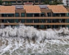
Severe weather doesn't always arrive as a single, predictable punch. Sometimes, nature coordinates its chaos. When Hurricane Simon and the remnants of Tropical Storm Rachel slammed into Mexico's Pacific coast, they left a trail of destruction that caught many communities off guard. Six people lost their lives as flash floods and heavy landslides ripped through multiple states. If you want to understand how modern weather systems can compound into regional crises, you have to look closely at what happened along the western coast of Mexico.
The disaster wasn't just about wind speeds. It was about water, timing, and geography. You might also find this similar article interesting: What We Trade for Ninety Seconds of Weightlessness.
The Anatomy of a Double-System Disaster
Most news outlets reported the bare minimum numbers. Five dead initially, then rising to six. But numbers hide the real human and logistical breakdown on the ground. Hurricane Simon churned offshore as a powerful Category 1 storm, pumping moisture northward while maintaining a menacing presence. At the exact same time, Tropical Storm Rachel dissolved into a moisture-laden remnant low that targeted Baja California with terrifying precision.
Think about what happens when heavy rain hits terrain that's already saturated. It has nowhere to go. As reported in recent articles by Reuters, the implications are significant.
In Ensenada, Baja California, the consequences turned fatal overnight. Residents like Johana Nuriulu described hearing a sound like massive ocean waves crashing inland. It wasn't the sea. It was an overflowing stream tearing through neighborhoods after power lines went down. Vehicles were swept away like toys. Homes filled with mud and debris within minutes.
Among the victims were a 13-year-old girl, two women in their thirties, and a 4-year-old boy. Entire families found themselves trapped by rising waters before emergency services could physically reach them. Security forces had to deploy helicopters just to pull dozens of stranded residents off rooftops and out of flash-flood zones.
Why the Pacific Coast is Vulnerable
Mexico's western geography creates a natural trap for tropical systems. Mountain ranges sit relatively close to the coastline. When moisture-heavy storms push inland from the Pacific, coastal cities absorb the immediate impact of high waves and storm surges, while interior slopes funnel rain into narrow canyons and riverbeds.
This creates instant flash flooding. You don't get days of slow-rising water. You get walls of runoff that move faster than cars can drive.
States like Nayarit, Sinaloa, Michoacan, and Guerrero faced severe alerts as rivers swelled past their banks. In Chilpancingo, down in Guerrero, a 71-year-old man died when a structural wall collapsed under the relentless pressure of storm rains. Further north, fishermen in San Felipe ventured out into the Gulf of California despite warnings, adding to the grim tally of missing persons as search boats scoured the choppy waters.
Meteorologists point out that Pacific hurricane seasons are growing increasingly volatile. Warmer ocean temperatures act as high-octane fuel for these systems, turning moderate storms into rapid-intensification threats. When overlapping weather patterns like Simon and Rachel merge their moisture plumes, emergency management agencies are forced to fight battles on multiple fronts simultaneously.
Preparing for Compound Weather Threats
Standard disaster preparedness assumes you're dealing with one clear threat. Board up the windows, stock up on water, wait for the eye to pass. But compound events change the rules.
If you live in or travel to hurricane-prone coastal regions, you need a different mental framework.
- Never underestimate remnants. A downgraded tropical storm or a post-landfall low can drop more inland water than a high-category hurricane. Rachel was "just" a remnant storm when it hit Baja California, yet it caused the highest local death toll.
- Watch the power grid. When electricity fails during a midnight storm, your situational awareness drops to zero. You can't hear flood sirens or see rising water levels until it hits your doorstep.
- Respect flash flood geography. Living near a stream or a canyon base means you are in a runoff pipe. Evacuate early when heavy rain warnings are issued, long before the water starts rising.
Recovery in Baja California and neighboring western states will take months. Roads cut off by massive landslides need rebuilding, infrastructure needs reinforcement, and families are left picking through the wreckage of homes swept away by midnight currents. Weather patterns will continue to test coastal defenses. Paying attention to early warnings remains the only reliable way to stay safe when the Pacific decides to unleash its worst.


