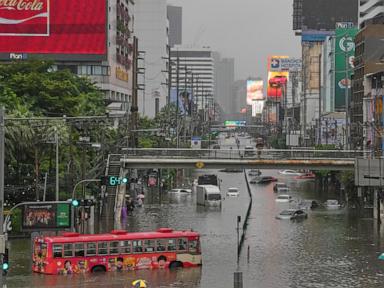
Precipitation anomalies in low-lying delta cities expose systemic vulnerabilities when aggregate runoff volume exceeds municipal drainage capacity. When severe meteorological events coincide with tidal cycles and high river levels, metropolitan infrastructure faces compounding failure points that disrupt civilian transit and force displacement. Urban flooding is rarely a simple meteorological issue. It represents an engineering failure where the rate of water accumulation vastly outpaces evacuation velocity, transforming thoroughfares into hydrological bottlenecks.
The Hydrological Equation of Delta Metropolises
Bangkok sits on a flat, low-lying delta of the Chao Phraya River, historically prone to seasonal inundation. Modern urban expansion has systematically replaced permeable soils, natural wetlands, and floodplains with impermeable asphalt, concrete, and high-density residential structures.
Total Surface Runoff = Precipitation Volume - (Infiltration + Evaporation + Storage Capacity)
As the impervious surface ratio approaches one hundred percent, infiltration drops to zero. Consequently, every millimeter of rainfall translates directly into surface runoff that must be managed entirely through artificial drainage vectors. When high-intensity rainfall delivers precipitation volumes that exceed pipe and canal design thresholds, water accumulates rapidly on street level.
Structural Bottlenecks in Drainage Networks
The movement of water through a major urban center relies on gravity-fed canals, pumping stations, and underground conduits. Several structural constraints limit the efficiency of this network during extreme weather events:
- Tidal Backpressure: The Chao Phraya River is tidal. When high tides coincide with heavy inland precipitation, the river level rises above the outfall points of urban drainage canals. This creates backpressure, effectively halting gravity-fed drainage and forcing water backward into the city streets.
- Pumping Capacity Mismatches: While municipal authorities deploy large-scale drainage pumps along primary canals, secondary and tertiary neighborhood drains often lack mechanical pumping assets. Water accumulates in residential sub-districts long before it reaches the main drainage channels.
- Debris Accumulation: Rapid surface runoff washes urban refuse, plastic waste, and organic debris into drainage inlets. This physical blockage reduces cross-sectional flow areas, choking pipe networks and rendering secondary channels ineffective.
Economic and Mobility Disruption Cascades
Traffic paralysis during major flood events follows a predictable cascade model. Initial street-level flooding slows vehicular speeds as drivers encounter hydroplaning risks and engine-inundation hazards. As water depths exceed twenty centimeters, passenger vehicles stall, blocking key transit arteries.
Public transportation networks experience cascading failures. Surface rail systems may operate, but feeder bus lines and pedestrian access routes become impassable. Commuters find themselves stranded, leading to widespread workforce absenteeism and immediate drops in retail and commercial productivity. The economic cost is calculated not just in structural property damage, but in lost labor hours and logistics delays across supply chains that rely on the affected transport corridors.
Managed Evacuation Protocols
When interior water levels rise to levels that threaten habitability and electrical safety, municipal authorities must execute evacuation protocols. These actions rely on threshold-based decision-making rather than arbitrary timelines.
- Inundation Depth Thresholds: Evacuation orders are triggered when water depth in residential zones exceeds levels that compromise ground-floor electrical infrastructure or prevent safe egress.
- Lifeline Severance: The disruption of potable water supplies, sanitation systems, and local power grids forces temporary population displacement, as sustained habitation becomes untenable.
- Temporary Shelter Allocation: Displaced populations are redirected to elevated public facilities outside the primary flood zones, requiring rapid coordination of logistical supplies, medical support, and security.
Infrastructure Adaptation Pathways
Mitigating recurrent urban inundation requires shifting from reactive emergency management to proactive structural adaptation. Cities facing similar geographic constraints must implement targeted engineering interventions to alter the hydrological balance.
- Retention Basin Expansion: Constructing subsurface retention vaults and preserving remaining peripheral wetlands creates temporary storage zones that absorb peak runoff volumes before they overwhelm canal networks.
- Smart Sluice Gate Automation: Integrating real-time telemetry with automated tidal gates allows operators to optimize drainage timing, opening and closing gates dynamically based on river levels and rainfall forecasts rather than manual schedules.
- Decentralized Permeable Pavements: Retrofitting urban hardscaping with permeable asphalt and green roofs increases localized infiltration, lowering peak runoff rates at the neighborhood level.
Systemic urban flooding in delta regions cannot be entirely prevented by emergency pumping alone. Long-term resilience demands a complete reassessment of land-use planning, treating water management as a core constraint of urban design rather than an auxiliary utility.